


Dublin City Walls app for iPhone and iPad
Developer: Noho Ltd.
First release : 06 Sep 2010
App size: 80.16 Mb
The City Walls iPhone app offers a unique guide to the medieval history of Dublin City. Using the historic city wall as its framework, it blends graphics, videos, photos and breathtaking 3D animations to bring the medieval world to life like never before.
City Walls functions as a walking tour for city visitors and residents, and a historical guide for anyone interested in the sites, stories and secrets of medieval Dublin, regardless of their location. Based on the popular Medieval Dublin boxset, the app will excite and delight viewers of all ages.
The app has two levels – city view and site view. When users open the app, they begin at the city view level. Here they are presented with a parchment map that traces the line of the old city wall. Towers, gates, prisons and other points of interest are all highlighted. The wall is color-coded to indicate which parts are still standing, which exist but are underground, and which have been destroyed and are only known through historical records. Users can pinch and zoom in to examine the wall and enjoy the style and texture of this parchment-style map.
Using the tabs on the bottom of the screen, users can access two more features in city view. The first is a detailed 3D model of Dublin as it is believed to have looked in 1540. Opening at a bird’s eye view high above the city, users can also pinch and zoom in on this image – right down to rooftop level. They can explore the layout of streets, the size and shape of houses, and the prominence of Dublin’s two cathedrals and its large stone castle.
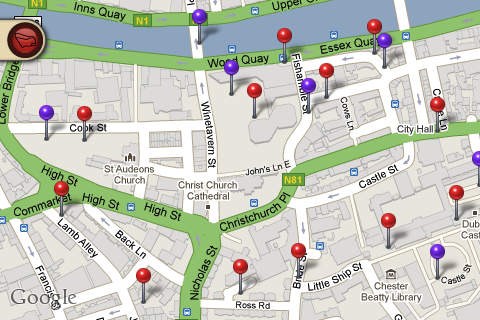
The third city view feature is a modern Google streetmap, with pins indicating the city wall sites. Users access this view to navigate the city and follow the walking tour. The Google map means they can easily see where they are and identify the next site to visit. At any time they can refer to the other two city views to get added context and a sense of the medieval city.
Level two of the City Walls app is called site view, and it contains video, photos and text content for each site along the wall. Users access the site view by touching any hotspot on the parchment map, or any pin on the Google streetmap.
When a user launches a hotspot, they are presented with a stylized image of the particular site, rich in period detail. Beside this there is a short text description of the site with information on its size, use and other details. Depending on what is known about the site, there up to three further tabs within each hotspot.
The first launches a short video (approx one minute) that uses 3D animations, 2D graphics and live action footage to provide a fascinating and visually spectacular overview of the site. The second tab guides users to a particular physical location and then presents a ‘before and after’ 3D animation that illustrates how that particular location looked in medieval times. The third tab contains archival photographs and further information based on excavations, archeological reports, etc.
From the moment users open the City Walls app, they will be captivated by its stunning visuals and realistic renditions of the medieval walled city. The City Walls interface blends a stylish parchment map, a 3D model and a modern streetmap to provide a rich understanding of city’s size and makeup.
The content is given added weight by the fact that it has been reviewed by a steering committee of leading Dublin scholars and archeologists. Whether a resident, tourist, or avid medievalist, there is something for everyone to enjoy in the City Walls app.